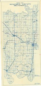
Road Map Seminole County, Oklahoma, 1939-01-01 - 1939-12-31
Item — Box: OS 2
Identifier: CAC_CC_007_9_2_2_31
Road Map Seminole County, Oklahoma, 1939-01-01 - 1939-12-31
Scope and Contents
Road Map of Seminole County, Oklahoma, created by William Roy Grace, County Engineer, features blue ink on white paper with red pencil markings. Dimensions: 37" x 17 3/4".
Dates
- Creation: 1939-01-01 - 1939-12-31
Creator
- From the Collection: Boren, Lyle Hagler, U.S. House of Representatives from Oklahoma's 4th district (1937-1947), 1909-1992 (Person)
Full Extent
1 pages
Language of Materials
From the Collection: English
Abstract
76th (1939-1941)
Repository Details
Part of the Carl Albert Center Congressional and Political Collections Repository