Civic-Commercial Map Directory, Shawnee, Oklahoma, 1943-01-01 - 1943-12-31
Item — Box: OS 2
Identifier: CAC_CC_007_9_2_2_17
Civic-Commercial Map Directory, Shawnee, Oklahoma, 1943-01-01 - 1943-12-31
Scope and Contents
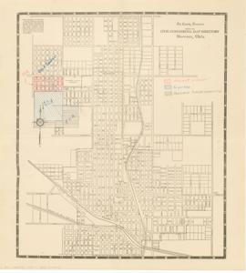
This Civic-Commercial Map Directory of Shawnee, Oklahoma, is a black and white map with colored pencil markings from The County Democrat. It depicts the airport location, including possible future expansion areas marked in pencil, and labels a golf course. Dimensions: 15 1/2" x 17".
Dates
- Creation: 1943-01-01 - 1943-12-31
Creator
- From the Collection: Boren, Lyle Hagler, U.S. House of Representatives from Oklahoma's 4th district (1937-1947), 1909-1992 (Person)
Full Extent
1 pages
Language of Materials
From the Collection: English
Abstract
78th (1943-1945)
Topical
Repository Details
Part of the Carl Albert Center Congressional and Political Collections Repository