Fort Sill Military Reservation, Comanche County, Oklahoma - Digitized, 1937-01-01 - 1937-12-31
Scope and Contents
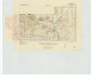
Create a concise and logical summary: CAC_CC_053_4_0000_1_168 is a tactical map produced by the Corps of Engineers, focusing on grid zone D. It illustrates shooting ranges at the fort, including various ranges, land areas in square miles, military boundaries, and forest reserves. Dimensions: The map covers several square miles of land as depicted.
Dates
- Creation: 1937-01-01 - 1937-12-31
Creator
- From the Collection: Thomas, Elmer, United States Senator from Oklahoma (1927-1951); U.S. House of Representatives from Oklahoma's 6th district (1923-1927); Member of the Oklahoma Senate (1907-1920), 1876-1965 (Person)
Language of Materials
English
Conditions Governing Access
Certain series of this collection are stored off-site and require prior notice to access. If you wish to view these materials, please contact the Congressional Archives staff to arrange an appointment.
The following series are stored off-site: Constituent Services, Miscellaneous, and Office Series.
Full Extent
1 pages
Abstract
75th (1937-1939)
Repository Details
Part of the Carl Albert Center Congressional and Political Collections Repository