Wichita Indian Meridian, 1919-06-01 - 1919-06-01
Scope and Contents
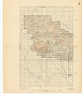
Create a concise and logical summary using the title "Topographical Map by Government Land Office" and the text: This topographical map, produced by the Government Land Office, includes a drawing on the back depicting Lake Lawton and its surrounding area, which aligns with the annotations on the map itself.
Dimensions: Not specified.
Dates
- Creation: 1919-06-01 - 1919-06-01
Creator
- From the Collection: Thomas, Elmer, United States Senator from Oklahoma (1927-1951); U.S. House of Representatives from Oklahoma's 6th district (1923-1927); Member of the Oklahoma Senate (1907-1920), 1876-1965 (Person)
Language of Materials
English
Conditions Governing Access
Certain series of this collection are stored off-site and require prior notice to access. If you wish to view these materials, please contact the Congressional Archives staff to arrange an appointment.
The following series are stored off-site: Constituent Services, Miscellaneous, and Office Series.
Full Extent
1 pages
Abstract
66th (1919-1921)
Repository Details
Part of the Carl Albert Center Congressional and Political Collections Repository