Oklahoma, State Highways, 1930-07-01
Scope and Contents
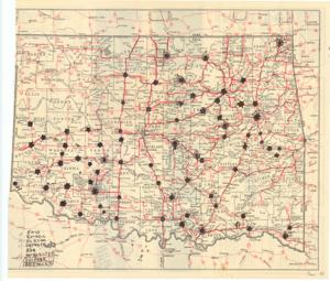
Create a concise and logical summary: This Road Map/Planning Map by the Oklahoma State Highway Commission highlights county seats in Oklahoma with stars and lists larger cities, featuring handwritten annotations on the back that include an itinerary of dates and cities for campaigning purposes.
Dimensions: Not specified in the provided information.
Dates
- Creation: 1930-07-01
Creator
- From the Collection: Thomas, Elmer, United States Senator from Oklahoma (1927-1951); U.S. House of Representatives from Oklahoma's 6th district (1923-1927); Member of the Oklahoma Senate (1907-1920), 1876-1965 (Person)
Language of Materials
English
Conditions Governing Access
Certain series of this collection are stored off-site and require prior notice to access. If you wish to view these materials, please contact the Congressional Archives staff to arrange an appointment.
The following series are stored off-site: Constituent Services, Miscellaneous, and Office Series.
Full Extent
1 pages
Abstract
71st (1929-1931)
Repository Details
Part of the Carl Albert Center Congressional and Political Collections Repository