State of Oklahoma, 1914-01-01 - 1914-12-31
Scope and Contents
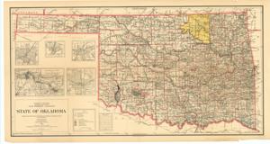
Create a concise and logical summary using the title from the TITLE column and the text in the summary. This survey map, titled "Survey map by Department of the Interior, General Land Office, I. P. Berthrong, chief of drafting," depicts Indian Territory, including towns, roads, Indian reservations, military reserves, land districts, and national forests. It is separated from the 72nd Map titled "Oil/Petroleum". Dimensions: Not specified.
Dates
- Creation: 1914-01-01 - 1914-12-31
Creator
- From the Collection: Thomas, Elmer, United States Senator from Oklahoma (1927-1951); U.S. House of Representatives from Oklahoma's 6th district (1923-1927); Member of the Oklahoma Senate (1907-1920), 1876-1965 (Person)
Language of Materials
English
Conditions Governing Access
Certain series of this collection are stored off-site and require prior notice to access. If you wish to view these materials, please contact the Congressional Archives staff to arrange an appointment.
The following series are stored off-site: Constituent Services, Miscellaneous, and Office Series.
Full Extent
1 pages
Abstract
63rd (1913-1915)
Repository Details
Part of the Carl Albert Center Congressional and Political Collections Repository