Wichita National Forest and Game Preserve, Oklahoma, Indian Meridian, 1923-01-01 - 1923-12-31
Item — Box: OS 1
Identifier: CAC_CC_053_4_0000_1_121B
Wichita National Forest and Game Preserve, Oklahoma, Indian Meridian, 1923-01-01 - 1923-12-31
Scope and Contents
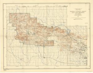
Topographical Map by the U.S. Department of Agriculture, Forest Service: This map depicts military boundaries, rivers, elevation, and wildlife boundaries, with the Indian Meridian referred to as I.M.
Dimensions: Not specified.
Dates
- Creation: 1923-01-01 - 1923-12-31
Creator
- From the Collection: Thomas, Elmer, United States Senator from Oklahoma (1927-1951); U.S. House of Representatives from Oklahoma's 6th district (1923-1927); Member of the Oklahoma Senate (1907-1920), 1876-1965 (Person)
Language of Materials
From the Collection:
English
Conditions Governing Access
Certain series of this collection are stored off-site and require prior notice to access. If you wish to view these materials, please contact the Congressional Archives staff to arrange an appointment.
The following series are stored off-site: Constituent Services, Miscellaneous, and Office Series.
Full Extent
1 pages
Abstract
68th (1923-1925)
Repository Details
Part of the Carl Albert Center Congressional and Political Collections Repository