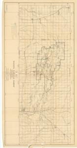
Wichita National Forest, Oklahoma, Indian Meridian, 1918-01-01 - 1918-12-31
Scope and Contents
Create a concise and logical summary using the title from the TITLE column and the text in the summary.
This geological map, produced by the U.S. Department of Agriculture, Forest Service, illustrates road conditions, campgrounds, springs, forest boundaries, and territory lines, with the Indian Meridian abbreviated as I.M.
Dimensions: Not specified in the provided data.
Dates
- Creation: 1918-01-01 - 1918-12-31
Creator
- From the Collection: Thomas, Elmer, United States Senator from Oklahoma (1927-1951); U.S. House of Representatives from Oklahoma's 6th district (1923-1927); Member of the Oklahoma Senate (1907-1920), 1876-1965 (Person)
Language of Materials
English
Conditions Governing Access
Certain series of this collection are stored off-site and require prior notice to access. If you wish to view these materials, please contact the Congressional Archives staff to arrange an appointment.
The following series are stored off-site: Constituent Services, Miscellaneous, and Office Series.
Full Extent
1 pages
Abstract
65th (1917-1919)
Topical
Repository Details
Part of the Carl Albert Center Congressional and Political Collections Repository