Oklahoma Federal Aid Sketch Map, 1913-01-01 - 1950-12-31
Scope and Contents
Create a concise and logical summary using the title from the TITLE column and the text in the summary.
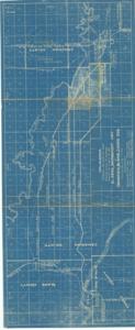
**Blueprint:** This map illustrates the location of the proposed Federal Aid Project Number 164 for the El Reno Bridgepoint Highway in Canadian, Blaine, and Caddo Counties, Oklahoma, highlighting US Highway 66, other roads, reserves, and county lines.
Dimensions: Not specified in the provided data.
Dates
- Creation: 1913-01-01 - 1950-12-31
Creator
- From the Collection: Thomas, Elmer, United States Senator from Oklahoma (1927-1951); U.S. House of Representatives from Oklahoma's 6th district (1923-1927); Member of the Oklahoma Senate (1907-1920), 1876-1965 (Person)
Language of Materials
English
Conditions Governing Access
Certain series of this collection are stored off-site and require prior notice to access. If you wish to view these materials, please contact the Congressional Archives staff to arrange an appointment.
The following series are stored off-site: Constituent Services, Miscellaneous, and Office Series.
Full Extent
1 pages
Abstract
63rd (1913-1915); 64th (1915-1917); 65th (1917-1919); 66th (1919-1921); 67th (1921-1923); 68th (1923-1925); 69th (1925-1927); 70th (1927-1929); 71st (1929-1931); 72nd (1931-1933); 73rd (1933-1935); 74th (1935-1937); 75th (1937-1939); 76th (1939-1941); 77th (1941-1943); 78th (1943-1945); 79th (1945-1947); 80th (1947-1949); 81st (1949-1951)
Topical
Repository Details
Part of the Carl Albert Center Congressional and Political Collections Repository