Land Ownership Map in Muskogee, Oklahoma, 1940-03-10
Item — Box: OS 1
Identifier: CAC_CC_053_4_0000_1_110
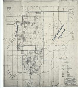
Land Ownership Map in Muskogee, Oklahoma, 1940-03-10
Scope and Contents
This map, titled CAC_CC_053_4_0000_1_110, is an ownership map produced by the U.S. Department of Agriculture, Soil Conservation Service. It illustrates a campsite and indicates a requirement for additional area.
Dimensions: Not specified in the data.
Dates
- Creation: 1940-03-10
Creator
- From the Collection: Thomas, Elmer, United States Senator from Oklahoma (1927-1951); U.S. House of Representatives from Oklahoma's 6th district (1923-1927); Member of the Oklahoma Senate (1907-1920), 1876-1965 (Person)
Language of Materials
From the Collection:
English
Conditions Governing Access
Certain series of this collection are stored off-site and require prior notice to access. If you wish to view these materials, please contact the Congressional Archives staff to arrange an appointment.
The following series are stored off-site: Constituent Services, Miscellaneous, and Office Series.
Full Extent
1 pages
Abstract
76th (1939-1941)
Repository Details
Part of the Carl Albert Center Congressional and Political Collections Repository