Outline Map of the United States, 1941-06-01 - 1941-06-01
Scope and Contents
Create a concise and logical summary using the title from the TITLE column and the text in the summary.
**Summary:**
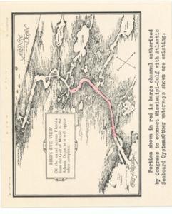
Coverage map by Henry H. Buckman illustrates the inland barge and pipeline transport and distribution of petroleum from mid-continent and gulf fields to the Eastern Seaboards, highlighting authorized, existing, proposed, and uncompleted pipelines.
Dimensions: Not specified in the provided data (refer to ID: CAC_CC_053_4_0000_1_87 for potential archive details).
Dates
- Creation: 1941-06-01 - 1941-06-01
Creator
- From the Collection: Thomas, Elmer, United States Senator from Oklahoma (1927-1951); U.S. House of Representatives from Oklahoma's 6th district (1923-1927); Member of the Oklahoma Senate (1907-1920), 1876-1965 (Person)
Language of Materials
English
Conditions Governing Access
Certain series of this collection are stored off-site and require prior notice to access. If you wish to view these materials, please contact the Congressional Archives staff to arrange an appointment.
The following series are stored off-site: Constituent Services, Miscellaneous, and Office Series.
Full Extent
1 pages
Abstract
77th (1941-1943)
Repository Details
Part of the Carl Albert Center Congressional and Political Collections Repository