Fort Gibson Dam, Grand (Neosho) River, Oklahoma, 1942-02-17
Scope and Contents
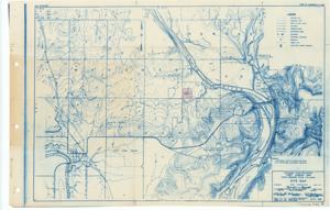
Create a concise and logical summary: This site map, produced by the War Department and the U.S. Army Corps of Engineers, illustrates township lines, right-of-way limits, railroads, improved roads, buildings, limestone quarry prospects, and elevations relative to mean sea level. Map dimensions: not specified in the provided data.
Dates
- Creation: 1942-02-17
Creator
- From the Collection: Thomas, Elmer, United States Senator from Oklahoma (1927-1951); U.S. House of Representatives from Oklahoma's 6th district (1923-1927); Member of the Oklahoma Senate (1907-1920), 1876-1965 (Person)
Language of Materials
English
Conditions Governing Access
Certain series of this collection are stored off-site and require prior notice to access. If you wish to view these materials, please contact the Congressional Archives staff to arrange an appointment.
The following series are stored off-site: Constituent Services, Miscellaneous, and Office Series.
Full Extent
1 pages
Abstract
77th (1941-1943)
Repository Details
Part of the Carl Albert Center Congressional and Political Collections Repository