Route Map of F.A.S. 5804, 1950-05-01 - 1950-05-31
Item — Box: OS 1
Identifier: CAC_CC_053_4_0000_1_60
Route Map of F.A.S. 5804, 1950-05-01 - 1950-05-31
Scope and Contents
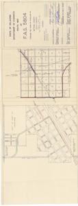
Route map by the Department of Highways, State of Oklahoma, depicting highways, construction, and approved and alternate routes through Fairland in Ottawa County, Oklahoma. Dimensions: 11 1/2" x 30".
Dates
- Creation: 1950-05-01 - 1950-05-31
Creator
- From the Collection: Thomas, Elmer, United States Senator from Oklahoma (1927-1951); U.S. House of Representatives from Oklahoma's 6th district (1923-1927); Member of the Oklahoma Senate (1907-1920), 1876-1965 (Person)
Language of Materials
From the Collection:
English
Conditions Governing Access
Certain series of this collection are stored off-site and require prior notice to access. If you wish to view these materials, please contact the Congressional Archives staff to arrange an appointment.
The following series are stored off-site: Constituent Services, Miscellaneous, and Office Series.
Full Extent
1 pages
Abstract
81st (1949-1951)
Topical
Repository Details
Part of the Carl Albert Center Congressional and Political Collections Repository