Post Route Map of Oklahoma, 1942-01-01 - 1942-01-31
Item — Box: OS 1
Identifier: CAC_CC_053_4_0000_1_31
Post Route Map of Oklahoma, 1942-01-01 - 1942-01-31
Scope and Contents
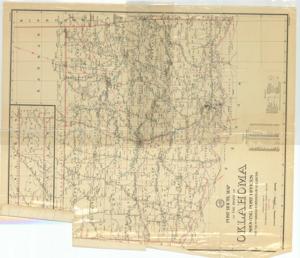
Coverage map by the United States Postal Service, featuring Post Offices with intermediate distances on mail routes, stations, county seats, rural and special delivery supplies, and railroads. Dimensions: 35 1/2" x 41 1/8".
Dates
- Creation: 1942-01-01 - 1942-01-31
Creator
- From the Collection: Thomas, Elmer, United States Senator from Oklahoma (1927-1951); U.S. House of Representatives from Oklahoma's 6th district (1923-1927); Member of the Oklahoma Senate (1907-1920), 1876-1965 (Person)
Language of Materials
From the Collection:
English
Conditions Governing Access
Certain series of this collection are stored off-site and require prior notice to access. If you wish to view these materials, please contact the Congressional Archives staff to arrange an appointment.
The following series are stored off-site: Constituent Services, Miscellaneous, and Office Series.
Full Extent
1 pages
Abstract
77th (1941-1943)
Topical
Repository Details
Part of the Carl Albert Center Congressional and Political Collections Repository