State of Oklahoma, 1914-01-01 - 1914-12-31
Item — Box: OS 1
Identifier: CAC_CC_053_4_0000_1_29
State of Oklahoma, 1914-01-01 - 1914-12-31
Scope and Contents
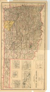
Coverage map by the Department of the Interior, General Land Office, featuring county boundaries, U.S. Land Offices, National Parks/Game Preserves, National Forests, Indian Reservations, Military Reservations, and smaller maps of larger townships and roads. Dimensions: 24" x 44"
Dates
- Creation: 1914-01-01 - 1914-12-31
Creator
- From the Collection: Thomas, Elmer, United States Senator from Oklahoma (1927-1951); U.S. House of Representatives from Oklahoma's 6th district (1923-1927); Member of the Oklahoma Senate (1907-1920), 1876-1965 (Person)
Language of Materials
From the Collection:
English
Conditions Governing Access
Certain series of this collection are stored off-site and require prior notice to access. If you wish to view these materials, please contact the Congressional Archives staff to arrange an appointment.
The following series are stored off-site: Constituent Services, Miscellaneous, and Office Series.
Full Extent
1 pages
Abstract
63rd (1913-1915)
Repository Details
Part of the Carl Albert Center Congressional and Political Collections Repository