Arkansas Valley, 1942-01-01 - 1942-12-31
Scope and Contents
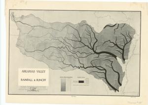
Create a concise and logical summary using the title from the TITLE column and the text in the summary. This document presents maps titled "Geological, Land Use and Land Survey Maps by the National Resources Planning Board," covering topics such as rainfall and runoff, irrigation projects, existing and proposed major recreation and wildlife areas, potential industrial expansion, water control and conservation projects, stream purification plans, major power facilities, and industrial minerals. It was removed from the Legislative Series, Subseries 81st Congress, Folder: Public Lands. Minerals Data. Dimensions: 11 1/2" x 16".
Dates
- Creation: 1942-01-01 - 1942-12-31
Creator
- From the Collection: Thomas, Elmer, United States Senator from Oklahoma (1927-1951); U.S. House of Representatives from Oklahoma's 6th district (1923-1927); Member of the Oklahoma Senate (1907-1920), 1876-1965 (Person)
Language of Materials
English
Conditions Governing Access
Certain series of this collection are stored off-site and require prior notice to access. If you wish to view these materials, please contact the Congressional Archives staff to arrange an appointment.
The following series are stored off-site: Constituent Services, Miscellaneous, and Office Series.
Full Extent
1 pages
Abstract
77th (1941-1943)
Repository Details
Part of the Carl Albert Center Congressional and Political Collections Repository