Map Of Wwi "Who Won World War?", 1929-01-01 - 1929-12-31
Item — Box: OS 1
Identifier: CAC_CC_010_13_0000_0000_42
Map Of Wwi "Who Won World War?", 1929-01-01 - 1929-12-31
Scope and Contents
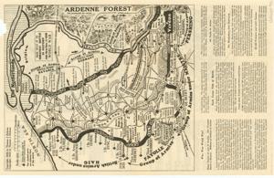
This map of WWI, titled "Who Won World War?", illustrates points of contact, enemy defense lines, major tactics employed, and the number of prisoners and cannons captured. Dimensions: 11 1/2" x 18".
Dates
- Creation: 1929-01-01 - 1929-12-31
Creator
- From the Collection: Cartwright, Wilburn, Oklahoma Corporation Commissioner (1955-1973); Oklahoma State Auditor (1951-1955); Oklahoma Secretary of State (1947-1951); Chairman of the Committee on Roads (1933-1943); Member of the U.S. House of Representatives from Oklahoma (192 (Person)
Language of Materials
From the Collection:
English
Conditions Governing Access
Certain series of this collection are stored off-site and require prior notice to access. If you wish to view these materials, please contact the Congressional Archives staff to arrange an appointment.
The Clippings series is stored off-site.
Full Extent
1 pages
Abstract
71st (1929-1931)
Repository Details
Part of the Carl Albert Center Congressional and Political Collections Repository