Oklahoma State Highway System, 1936-01-01 - 1936-12-31
Item — Box: OS 1
Identifier: CAC_CC_010_13_0000_0000_40
Oklahoma State Highway System, 1936-01-01 - 1936-12-31
Scope and Contents
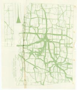
The Oklahoma State Highway System map from 1936 illustrates traffic density on state and Federal Aid highways in Oklahoma, based on data from March to October. Dimensions: 17" x 20".
Dates
- Creation: 1936-01-01 - 1936-12-31
Creator
- From the Collection: Cartwright, Wilburn, Oklahoma Corporation Commissioner (1955-1973); Oklahoma State Auditor (1951-1955); Oklahoma Secretary of State (1947-1951); Chairman of the Committee on Roads (1933-1943); Member of the U.S. House of Representatives from Oklahoma (192 (Person)
Language of Materials
From the Collection:
English
Conditions Governing Access
Certain series of this collection are stored off-site and require prior notice to access. If you wish to view these materials, please contact the Congressional Archives staff to arrange an appointment.
The Clippings series is stored off-site.
Full Extent
1 pages
Abstract
74th (1935-1937)
Repository Details
Part of the Carl Albert Center Congressional and Political Collections Repository