Partial Map Of Southeastern Oklahoma., 1915-01-01 - 1915-12-31
Scope and Contents
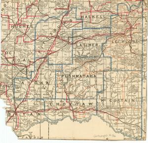
The Partial Map of Southeastern Oklahoma, dating from 1915-1949, shows the outline of counties. Dimensions: 9 3/4" x 10 1/4".
Dates
- Creation: 1915-01-01 - 1915-12-31
Creator
- From the Collection: Cartwright, Wilburn, Oklahoma Corporation Commissioner (1955-1973); Oklahoma State Auditor (1951-1955); Oklahoma Secretary of State (1947-1951); Chairman of the Committee on Roads (1933-1943); Member of the U.S. House of Representatives from Oklahoma (192 (Person)
Language of Materials
English
Conditions Governing Access
Certain series of this collection are stored off-site and require prior notice to access. If you wish to view these materials, please contact the Congressional Archives staff to arrange an appointment.
The Clippings series is stored off-site.
Full Extent
1 pages
Abstract
64th (1915-1917); 65th (1917-1919); 66th (1919-1921); 67th (1921-1923); 68th (1923-1925); 69th (1925-1927); 70th (1927-1929); 71st (1929-1931); 72nd (1931-1933); 73rd (1933-1935); 74th (1935-1937); 75th (1937-1939); 76th (1939-1941); 77th (1941-1943); 78th (1943-1945); 79th (1945-1947); 80th (1947-1949); 81st (1949-1951)
Repository Details
Part of the Carl Albert Center Congressional and Political Collections Repository