Coal Map, 1933-01-01 - 1933-12-31
Item — Box: OS 1
Identifier: CAC_CC_010_13_0000_0000_6
Coal Map, 1933-01-01 - 1933-12-31
Scope and Contents
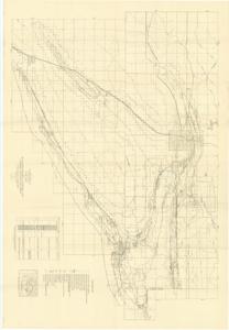
Coal Map: This geological survey map depicts the McAlester district in Pittsburg and Latimer counties, Oklahoma, from 1933. Dimensions: 44" x 63".
Dates
- Creation: 1933-01-01 - 1933-12-31
Creator
- From the Collection: Cartwright, Wilburn, Oklahoma Corporation Commissioner (1955-1973); Oklahoma State Auditor (1951-1955); Oklahoma Secretary of State (1947-1951); Chairman of the Committee on Roads (1933-1943); Member of the U.S. House of Representatives from Oklahoma (192 (Person)
Language of Materials
From the Collection:
English
Conditions Governing Access
Certain series of this collection are stored off-site and require prior notice to access. If you wish to view these materials, please contact the Congressional Archives staff to arrange an appointment.
The Clippings series is stored off-site.
Full Extent
1 pages
Abstract
73rd (1933-1935)
Repository Details
Part of the Carl Albert Center Congressional and Political Collections Repository