Traffic Density On Oklahoma State And Federal Aid Highways, 1930-01-01 - 1930-12-31
Item — Box: OS 1
Identifier: CAC_CC_010_13_0000_0000_3
Traffic Density On Oklahoma State And Federal Aid Highways, 1930-01-01 - 1930-12-31
Scope and Contents
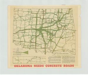
This map, titled "Traffic Density On Oklahoma State And Federal Aid Highways" (from the 1915-1949 series, specifically 1930-01), illustrates existing high-type pavement, secondary pavement, and unpaved roads, with an overlay depicting traffic density and use. It was created as a promotional piece by the Portland Cement Association. Dimensions: 17" x 20".
Dates
- Creation: 1930-01-01 - 1930-12-31
Creator
- From the Collection: Cartwright, Wilburn, Oklahoma Corporation Commissioner (1955-1973); Oklahoma State Auditor (1951-1955); Oklahoma Secretary of State (1947-1951); Chairman of the Committee on Roads (1933-1943); Member of the U.S. House of Representatives from Oklahoma (192 (Person)
Language of Materials
From the Collection:
English
Conditions Governing Access
Certain series of this collection are stored off-site and require prior notice to access. If you wish to view these materials, please contact the Congressional Archives staff to arrange an appointment.
The Clippings series is stored off-site.
Full Extent
1 pages
Abstract
71st (1929-1931)
Repository Details
Part of the Carl Albert Center Congressional and Political Collections Repository