Pittsburg County, Oklahoma, 1925-01-01 - 1925-12-31
Item — Box: OS 1
Identifier: CAC_CC_010_13_0000_0000_2
Pittsburg County, Oklahoma, 1925-01-01 - 1925-12-31
Scope and Contents
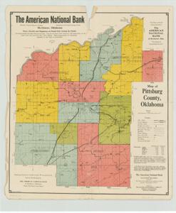
A color map of Pittsburg County, Oklahoma (1925), featuring state roads, county highways, bridges, townships, railroads, rivers, schools, post offices, town populations, and economic information. Produced by McAlester Engineering Company for American National Bank of McAlester. Dimensions: 18 3/4" x 22".
Dates
- Creation: 1925-01-01 - 1925-12-31
Creator
- From the Collection: Cartwright, Wilburn, Oklahoma Corporation Commissioner (1955-1973); Oklahoma State Auditor (1951-1955); Oklahoma Secretary of State (1947-1951); Chairman of the Committee on Roads (1933-1943); Member of the U.S. House of Representatives from Oklahoma (192 (Person)
Language of Materials
From the Collection:
English
Conditions Governing Access
Certain series of this collection are stored off-site and require prior notice to access. If you wish to view these materials, please contact the Congressional Archives staff to arrange an appointment.
The Clippings series is stored off-site.
Full Extent
1 pages
Abstract
69th (1925-1927)
Repository Details
Part of the Carl Albert Center Congressional and Political Collections Repository