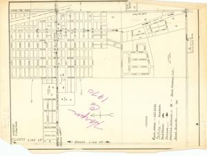
Map of a Parade Route. 1970., 1970-01-01 - 1970-12-31
Scope and Contents
Map of a Parade Route. 1970.
This map outlines the parade route from 1970, detailing the streets and landmarks involved. It provides a visual guide for participants and spectators, ensuring a smooth flow of the event. The map dimensions are 24 x 36 inches.
Dates
- Creation: 1970-01-01 - 1970-12-31
Creator
- From the Collection: Bartlett, Dewey Follett, Sr., 19th Governor of Oklahoma (1967-1971); United States Senator from Oklahoma (1973-1979); Member of the Oklahoma Senate from the 39th district (1962-1966), 1919-1979 (Person)
Language of Materials
English
Conditions Governing Access
Certain series of this collection are stored off-site and require prior notice to access. If you wish to view these materials, please contact the Congressional Archives staff to arrange an appointment.
The following series are stored off-site: Clippings and Books.
Bartlett, Legislative Series, Box 14 is stored off-site. These materials are currently closed to researchers.
Full Extent
1 pages
Abstract
91st (1969-1971)
Repository Details
Part of the Carl Albert Center Congressional and Political Collections Repository