"3-District" Plan, 1964-04-01
Item — Box: OS 5
Identifier: CAC_CC_038_14_0000_5_182
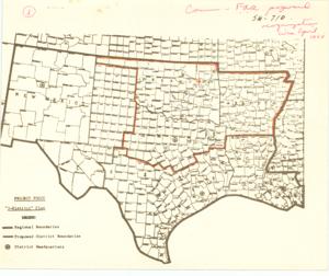
"3-District" Plan, 1964-04-01
Scope and Contents
This historical regional map, measuring 8 1/2 by 10 5/16 inches and labeled SW-710, depicts the proposed district boundaries as part of a reorganization plan from around April 1964. It was originally attached to Item 183 and includes annotations and inscriptions.
Dates
- Creation: 1964-04-01
Creator
- From the Collection: Monroney, Almer Stillwell (Mike), United States Senator from Oklahoma (1951-1969); U.S. House of Representatives from Oklahoma's 5th district (1939-1951), 1902-1980 (Person)
Language of Materials
From the Collection:
English
Full Extent
1 pages
Abstract
88th (1963-1965)
Repository Details
Part of the Carl Albert Center Congressional and Political Collections Repository