I-40 and US 66 from Oklahoma City West, 1962-10-24
Scope and Contents
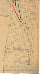
The document represents a map item is a topographic map depicting I-40 and U.S. Highway 66 from Oklahoma City west to Texas. Map features color-coded taped routes. Green indicates a "route as originally proposed and approved." Red indicates a "route as revised and approved." Dashed Red indicates "city routes constructed." Taped routes were added to an existing map revised on August 4, 1955, titled, "State of Oklahoma Department of Highways Route Map of Interstate Federal-Aid Primary Route on US Highway 66." Topographic map (diazotype, blueline print); 22 3/4 x 165 11/16 inches.
Dates
- Creation: 1962-10-24
Creator
- From the Collection: Kerr, Robert Samuel, United States Senator from Oklahoma (1949-1963); 12th Governor of Oklahoma (1943-1947), 1896-1963 (Person)
Language of Materials
English
Conditions Governing Access:
Certain series of this collection are stored off-site and require prior notice to access. If you wish to view these materials, please contact the Congressional Archives staff to arrange an appointment.
The following series are stored off-site: Clippings and Invitations.
Full Extent
1 pages
Abstract
87th (1961-1963)
Repository Details
Part of the Carl Albert Center Congressional and Political Collections Repository