Project Map, Upper Blue River Watershed, 1961-10-01
Item — Box: OS 9
Identifier: CAC_CC_031_14_0000_9_275
Project Map, Upper Blue River Watershed, 1961-10-01
Scope and Contents
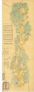
The document represents a map item is a map of the Upper Blue River Watershed in Atoka, Bryan, Johnston, Murray, and Pontotoc Counties, Oklahoma. Map features various sites and drainage areas from water projects. Watershed map (diazotype, blackline print; color); 16 x 46 3/4 inches; Figure 3; 4-R-15997.
Dates
- Creation: 1961-10-01
Creator
- From the Collection: Kerr, Robert Samuel, United States Senator from Oklahoma (1949-1963); 12th Governor of Oklahoma (1943-1947), 1896-1963 (Person)
Language of Materials
From the Collection:
English
Conditions Governing Access:
Certain series of this collection are stored off-site and require prior notice to access. If you wish to view these materials, please contact the Congressional Archives staff to arrange an appointment.
The following series are stored off-site: Clippings and Invitations.
Full Extent
1 pages
Abstract
87th (1961-1963)
Repository Details
Part of the Carl Albert Center Congressional and Political Collections Repository