Surface Geology of Area between Oklahoma City and Shawnee, 1937-1962
Scope and Contents
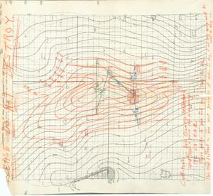
The document represents a map item is a contour map with the "Ellison-Hollenback and Anderson-Kerr Block" shaded in salmon marker. There are additional hand-drawn contours in orange along with annotations in green and blue pertaining to either the geology or specific locations of the area. Supplementary annotations in orange are located at the bottom of the map. Inscribed (top edge; orange): PLEASE DO NOT DESTROY. Contour map (positive photostat print); 19 7/16 x 17 7/8 inches; Shading (salmon, marker) of Ellison-Hollenback and Anderson-Kerr Block; Annotations (orange, green, blue).
Dates
- Creation: 1937-1962
Creator
- From the Collection: Kerr, Robert Samuel, United States Senator from Oklahoma (1949-1963); 12th Governor of Oklahoma (1943-1947), 1896-1963 (Person)
Language of Materials
English
Conditions Governing Access:
Certain series of this collection are stored off-site and require prior notice to access. If you wish to view these materials, please contact the Congressional Archives staff to arrange an appointment.
The following series are stored off-site: Clippings and Invitations.
Full Extent
1 pages
Abstract
75th (1937-1939); 76th (1939-1941); 77th (1941-1943); 78th (1943-1945); 79th (1945-1947); 80th (1947-1949); 81st (1949-1951); 82nd (1951-1953); 83rd (1953-1955); 84th (1955-1957); 85th (1957-1959); 86th (1959-1961); 87th (1961-1963)
Repository Details
Part of the Carl Albert Center Congressional and Political Collections Repository