Ward and Precinct Map, Oklahoma City, Oklahoma, 1937-02-01
Scope and Contents
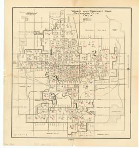
The document represents a map item is a historical map of Wards 1 through 4 and their precincts in Oklahoma City Oklahoma. Precincts are inscribed with "y."s and "no."s as well as numbers, which appear to be the outcome of a vote; the precincts that had more "no" votes are marked with red Xs. On verso of map, there are names inscribed. Two documents were attached to this map including another map. The first document (262-1) consists of a table of precinct numbers, wards, chairpersons, and persons making contact. The second document (262-2) is a smaller sheet of paper listing the number of precincts lost and won in each ward with totals. Historical map; 18 1/2 x17 1/16 inches; Inscriptions (within precincts; black pen; red pencil); Inscriptions (verso; black pen; blue pen; pencil) on verso of names.
Dates
- Creation: 1937-02-01
Creator
- From the Collection: Kerr, Robert Samuel, United States Senator from Oklahoma (1949-1963); 12th Governor of Oklahoma (1943-1947), 1896-1963 (Person)
Language of Materials
English
Conditions Governing Access:
Certain series of this collection are stored off-site and require prior notice to access. If you wish to view these materials, please contact the Congressional Archives staff to arrange an appointment.
The following series are stored off-site: Clippings and Invitations.
Full Extent
1 pages
Abstract
75th (1937-1939)
Repository Details
Part of the Carl Albert Center Congressional and Political Collections Repository