Oklahoma
Scope and Contents
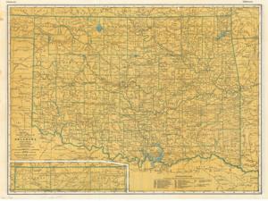
The document represents a map item consists of two maps, one on each side of the support. One map is titled "Rand McNally Road Map" and features highways, roadways, parks, points of interest, and airports. The other map is titled "Rand McNally Standard Map of Oklahoma" and features the topography and railroads of the state. Road map, topographic map (gel-lithograph; color); 201/8 x 27 1/16 inches.
Dates
- Creation: 1937-01-01 - 1962-12-31
Creator
- From the Collection: Kerr, Robert Samuel, United States Senator from Oklahoma (1949-1963); 12th Governor of Oklahoma (1943-1947), 1896-1963 (Person)
Language of Materials
English
Conditions Governing Access:
Certain series of this collection are stored off-site and require prior notice to access. If you wish to view these materials, please contact the Congressional Archives staff to arrange an appointment.
The following series are stored off-site: Clippings and Invitations.
Full Extent
1 pages
Abstract
76th (1939-1941)
Repository Details
Part of the Carl Albert Center Congressional and Political Collections Repository