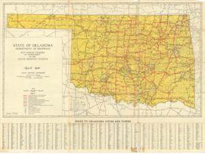
Map Showing Condition of Improvement of the State Highway System, April, 1940
Scope and Contents
The document represents a map official State Highway Map of Oklahoma Topographic, road map (gel-lithograph; color); 19 15/16 x 26 7/8 inches; Inscribed (brochure cover; black, pen): France Paris; Inscribed (below Oklahoma in Texas; pencil); Annotations (circles; 15/16 inch diameter; blue) around Alva, Vinita, Muskogee, Cordell, Medicine Park, Purcell, Wewoka/Holdenville, Atoka, Marietta; Annotations (circled; red) around cities: Grand, Walters, Comanche, Temple, Hastings, Waurika, Ringling, Wilson, Healdton.
Dates
- Creation: April, 1940
Creator
- From the Collection: Kerr, Robert Samuel, United States Senator from Oklahoma (1949-1963); 12th Governor of Oklahoma (1943-1947), 1896-1963 (Person)
Language of Materials
English
Conditions Governing Access:
Certain series of this collection are stored off-site and require prior notice to access. If you wish to view these materials, please contact the Congressional Archives staff to arrange an appointment.
The following series are stored off-site: Clippings and Invitations.
Full Extent
1 pages
Abstract
76th (1939-1941)
Repository Details
Part of the Carl Albert Center Congressional and Political Collections Repository