Map of Oklahoma's State Highway System, 1940-01-01 - 1940-12-31
Item — Box: OS 9
Identifier: CAC_CC_031_14_0000_9_254
Map of Oklahoma's State Highway System, 1948-01-01 - 1948-12-31
Scope and Contents
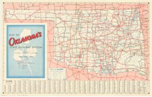
The document represents a map item is a topographic map of the State of Oklahoma featuring the state's highway system. Included on the verso is a "Pictorial Map of Oklahoma," which shows various recreational, scenic, and historical locations. Topographic, road map (pictorial map; gel-lithograph; color); 21 3/8 x 34 inches.
Dates
- Creation: 1940-01-01 - 1940-12-31
Creator
- From the Collection: Kerr, Robert Samuel, United States Senator from Oklahoma (1949-1963); 12th Governor of Oklahoma (1943-1947), 1896-1963 (Person)
Language of Materials
From the Collection:
English
Conditions Governing Access:
Certain series of this collection are stored off-site and require prior notice to access. If you wish to view these materials, please contact the Congressional Archives staff to arrange an appointment.
The following series are stored off-site: Clippings and Invitations.
Full Extent
1 pages
Abstract
80th (1947-1949)
Repository Details
Part of the Carl Albert Center Congressional and Political Collections Repository