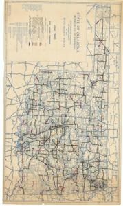
Map Showing Condition of Improvement of the State Highway System, June, 1945
Item — Box: OS 8
Identifier: CAC_CC_031_14_0000_8_245
Map Showing Condition of Improvement of the State Highway System, 1945-06-06
Scope and Contents
The document represents a map map indicates various federal and state highways programs and other projects throughout the state, each are color-coded by program. Topographic, road map (diazotype, blueline print); 30 1/2 x 52 3/4 inches.
Dates
- Creation: June, 1945
Creator
- From the Collection: Kerr, Robert Samuel, United States Senator from Oklahoma (1949-1963); 12th Governor of Oklahoma (1943-1947), 1896-1963 (Person)
Language of Materials
From the Collection:
English
Conditions Governing Access:
Certain series of this collection are stored off-site and require prior notice to access. If you wish to view these materials, please contact the Congressional Archives staff to arrange an appointment.
The following series are stored off-site: Clippings and Invitations.
Full Extent
1 pages
Abstract
79th (1945-1947)
Repository Details
Part of the Carl Albert Center Congressional and Political Collections Repository