Preliminary Proposed Alignment for U.S. 59, 1934-01-01 - 1962-12-31
Scope and Contents
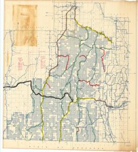
The document represents a map item is a topographic map of McCurtain County and the southern half of Le Flore County in Oklahoma. Item consists of three separate sections that were previously taped together; sections align north to south from Section 1 (of 3) to Section 3 (of 3). Map highlights roadways throughout and near Ouachita National Forest. Featured on the map, annotated in black, is U.S. Highway 59, which is accompanied by various inscriptions in red ink stating the length of highway sections and costs for grading, drainage, bridges, and paving. Included with item is the legend, which is detached. Topographic map (diazotype, blueline print); 33 3/8 x 36 inches (Section 1); 30 5/8 x 35 5/8 inches (Section 2); 33 3/8 x 33 15/16 (Section 3); Annotations (lines; dotted lines; green, yellow, red, brown, black; marker; Inscribed (distances; costs; red, ink).
Dates
- Creation: 1934-01-01 - 1962-12-31
Creator
- From the Collection: Kerr, Robert Samuel, United States Senator from Oklahoma (1949-1963); 12th Governor of Oklahoma (1943-1947), 1896-1963 (Person)
Language of Materials
English
Conditions Governing Access:
Certain series of this collection are stored off-site and require prior notice to access. If you wish to view these materials, please contact the Congressional Archives staff to arrange an appointment.
The following series are stored off-site: Clippings and Invitations.
Full Extent
1 pages
Abstract
73rd (1933-1935); 74th (1935-1937); 75th (1937-1939); 76th (1939-1941); 77th (1941-1943); 78th (1943-1945); 79th (1945-1947); 80th (1947-1949); 81st (1949-1951); 82nd (1951-1953); 83rd (1953-1955); 84th (1955-1957); 85th (1957-1959); 86th (1959-1961); 87th (1961-1963)
Repository Details
Part of the Carl Albert Center Congressional and Political Collections Repository