Conservation Plan Map, Kerr Farms, 1960-10-12
Scope and Contents
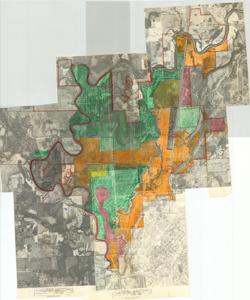
The document represents a plan item is a hand-colored, topographic map and apparent conservation plan of Kerr Farms in Le Flore County, Oklahoma. The conservation plan was conducted in units and mapped on five separate aerial photographs. Photo number BQI-4K-116 comprised of Unit: Pickle-Wood-Huddleston-Best-Crane, which consisted of approximately 1370 acres. Photo number BQI-6K-158 comprised of Unit: Fox Wood III-Huddleston-Jackson, which consisted of approximately 560 acres. Photo number BQI-4K-66 comprised of Unit: Leo Best Place, which consisted of approximately 1015 acres. Photo number BQI-6K-160 comprised of Unit: Armstrong-Bend-Reese, which consisted of approximately 589 acres. Photo number BQI-5K-206 comprised of Unit: Higginbotham-Westbrook-Woods-Huddleston, which consisted of approximately 770 acres. Topographic map (photograph, aerial); 43 1/8 x 38 inches; Annotations and Shading (red, orange, yellow, green, black; wax crayons).
Dates
- Creation: 1960-10-12
Creator
- From the Collection: Kerr, Robert Samuel, United States Senator from Oklahoma (1949-1963); 12th Governor of Oklahoma (1943-1947), 1896-1963 (Person)
Language of Materials
English
Conditions Governing Access:
Certain series of this collection are stored off-site and require prior notice to access. If you wish to view these materials, please contact the Congressional Archives staff to arrange an appointment.
The following series are stored off-site: Clippings and Invitations.
Full Extent
1 pages
Abstract
86th (1959-1961)
Repository Details
Part of the Carl Albert Center Congressional and Political Collections Repository