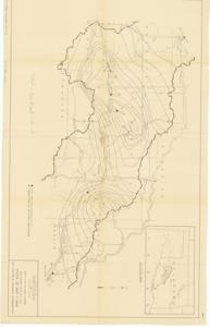
Map Showing Isohyetals for Storm of May 17, 1949 and Locations of Discharge Determinations, May 17, 1949
Item — Box: OS 8
Identifier: CAC_CC_031_14_0000_8_227
Map Showing Isohyetals for Storm of May 17, 1949 and Locations of Discharge Determinations, 1949-01-01 - 1949-12-31
Scope and Contents
The document represents a map item is a weather (isohyetal) map of the Washita River Sub-Basin in Oklahoma, which depicts the amount of rainfall as well as the locations of peak flow from the May 17, 1947 storm. Weather map (hydrologic map); 21 1/16 x 33 5/16; Plate 3.
Dates
- Creation: May 17, 1949
Creator
- From the Collection: Kerr, Robert Samuel, United States Senator from Oklahoma (1949-1963); 12th Governor of Oklahoma (1943-1947), 1896-1963 (Person)
Language of Materials
From the Collection:
English
Conditions Governing Access:
Certain series of this collection are stored off-site and require prior notice to access. If you wish to view these materials, please contact the Congressional Archives staff to arrange an appointment.
The following series are stored off-site: Clippings and Invitations.
Full Extent
1 pages
Abstract
81st (1949-1951)
Repository Details
Part of the Carl Albert Center Congressional and Political Collections Repository