Mean Annual Precipitation, Little River and Tributaries, 1947-12-30
Item — Box: OS 7
Identifier: CAC_CC_031_14_0000_7_226
Mean Annual Precipitation, Little River and Tributaries, 1947-12-30
Scope and Contents
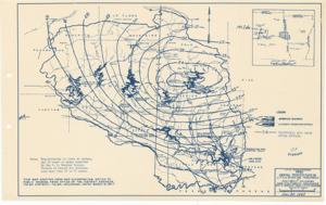
The document represents a map item is a weather (isohyetal) map depicting the mean annual precipitation of the Little River watershed area in Southeast Oklahoma and Southwest Arkansas. Weather map (hydrologic map; diazotype, blueline print); 10 7/8 x 17 9/16 inches.
Dates
- Creation: 1947-12-30
Creator
- From the Collection: Kerr, Robert Samuel, United States Senator from Oklahoma (1949-1963); 12th Governor of Oklahoma (1943-1947), 1896-1963 (Person)
Language of Materials
From the Collection:
English
Conditions Governing Access:
Certain series of this collection are stored off-site and require prior notice to access. If you wish to view these materials, please contact the Congressional Archives staff to arrange an appointment.
The following series are stored off-site: Clippings and Invitations.
Full Extent
1 pages
Abstract
80th (1947-1949)
Repository Details
Part of the Carl Albert Center Congressional and Political Collections Repository