Storm of May 12, 1947, Little River and Tributaries, June 9, 1947
Scope and Contents
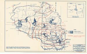
The document represents a plan item is a weather (isohyetal) map of the Little River watershed area in Southeast Oklahoma and Southwest Arkansas, which depicts the amount of rainfall from the May 12, 1947 storm. This item was "To accompany report dated June 9, 1947." Isolines of weather map were drawn in red pencil over a map titled: Plan of Proposed Flood Control, Little River and Tributaries. Weather map (hydrologic map; diazotype, blueline print); 10 15/16 x 17 11/16 inches.
Dates
- Creation: June 9, 1947
Creator
- From the Collection: Kerr, Robert Samuel, United States Senator from Oklahoma (1949-1963); 12th Governor of Oklahoma (1943-1947), 1896-1963 (Person)
Language of Materials
English
Conditions Governing Access:
Certain series of this collection are stored off-site and require prior notice to access. If you wish to view these materials, please contact the Congressional Archives staff to arrange an appointment.
The following series are stored off-site: Clippings and Invitations.
Full Extent
1 pages
Abstract
80th (1947-1949)
Repository Details
Part of the Carl Albert Center Congressional and Political Collections Repository