Arkansas River, Navigation Projects, August 27-29, 1947
Scope and Contents
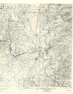
The document represents a map item is a topographic map of Muskogee and its vicinity that features the Arkansas, Verdigris, and Neosho Rivers highlighted in blue and the Missouri, Kansas, and Texas Railroad outlined in red. Indicated on the map with a red triangle and labeled is the approximate location of the Webbers Falls Lock and Dam. Also labeled with an arrow is the "proposed navigable waterway from mouth of Arkansas River to Catoosa, Okla." Topographic map (contour map; polyconic projection; positive photostat print); 22 11/16 x 17 13/16 inches; Annotations (highlights, blue; outlines, red).
Dates
- Creation: August 27-29, 1947
Creator
- From the Collection: Kerr, Robert Samuel, United States Senator from Oklahoma (1949-1963); 12th Governor of Oklahoma (1943-1947), 1896-1963 (Person)
Language of Materials
English
Conditions Governing Access:
Certain series of this collection are stored off-site and require prior notice to access. If you wish to view these materials, please contact the Congressional Archives staff to arrange an appointment.
The following series are stored off-site: Clippings and Invitations.
Full Extent
1 pages
Abstract
76th (1939-1941); 77th (1941-1943); 78th (1943-1945); 79th (1945-1947); 80th (1947-1949)
Repository Details
Part of the Carl Albert Center Congressional and Political Collections Repository