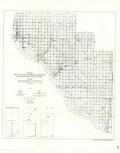
Map of Parts of Alfalfa, Garfield, Kingfisher, and Major Counties, Oklahoma, 1939-1974
Item — Box: OS 7
Identifier: CAC_CC_031_14_0000_7_218
Map of Parts of Alfalfa, Garfield, Kingfisher, and Major Counties, Oklahoma, 1939-01-01 - 1974-12-31
Scope and Contents
The document represents a map item is contour and hydrologic map "showing generalized contours on the water table; location of water wells, test holes, and shot holes." Contour map (hydrologic map; geological map); 24 1/16 x 19 1/16 inches; Plate 5.
Dates
- Creation: 1939-1974
Creator
- From the Collection: Kerr, Robert Samuel, United States Senator from Oklahoma (1949-1963); 12th Governor of Oklahoma (1943-1947), 1896-1963 (Person)
Language of Materials
From the Collection:
English
Conditions Governing Access:
Certain series of this collection are stored off-site and require prior notice to access. If you wish to view these materials, please contact the Congressional Archives staff to arrange an appointment.
The following series are stored off-site: Clippings and Invitations.
Full Extent
1 pages
Abstract
76th (1939-1941); 77th (1941-1943); 78th (1943-1945); 79th (1945-1947); 80th (1947-1949)
Repository Details
Part of the Carl Albert Center Congressional and Political Collections Repository