Arkansas Corporation Commission Official Map, 1939
Scope and Contents
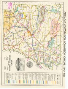
The document represents a map item is a transportation map of the Arkansas Railroads, which are color-coded. Map features locations of mineral resources, which are indicated by color-coded shading and annotations. Annotations (pink, pencil): "Numbers and arrows indicate minimum river flow in C.F.S." Mineral resource map (transportation map; color); 16 7/8 x 21 7/8 inches; Annotations and Shading (color-coded by hand; various colors, pencil) of mineral resources in Arkansas.
Dates
- Creation: 1939
Creator
- From the Collection: Kerr, Robert Samuel, United States Senator from Oklahoma (1949-1963); 12th Governor of Oklahoma (1943-1947), 1896-1963 (Person)
Language of Materials
English
Conditions Governing Access:
Certain series of this collection are stored off-site and require prior notice to access. If you wish to view these materials, please contact the Congressional Archives staff to arrange an appointment.
The following series are stored off-site: Clippings and Invitations.
Full Extent
1 pages
Abstract
76th (1939-1941)
Repository Details
Part of the Carl Albert Center Congressional and Political Collections Repository