Irrigated and Non-Irrigated Lands in the United States, 1944-05-01
Scope and Contents
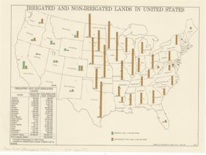
The document represents a map item depicts a map of the continental United States with color-coded bar graphs of land irrigation status by 2 million acres for each state. A table of acreage for states with both irrigated and non-irrigated lands is included. Charts (graphic documents; map, national); 10 1/2 x 14 1/8 inches; Map No. 44-2; A.M.S.
Dates
- Creation: 1944-05-01
Creator
- From the Collection: Kerr, Robert Samuel, United States Senator from Oklahoma (1949-1963); 12th Governor of Oklahoma (1943-1947), 1896-1963 (Person)
Language of Materials
English
Conditions Governing Access:
Certain series of this collection are stored off-site and require prior notice to access. If you wish to view these materials, please contact the Congressional Archives staff to arrange an appointment.
The following series are stored off-site: Clippings and Invitations.
Full Extent
1 pages
Abstract
78th (1943-1945)
Repository Details
Part of the Carl Albert Center Congressional and Political Collections Repository