U.S. Department of the Interior, Five Civilized Tribes, Delaware Project Area, Grazing Areas, 1939-1974
Scope and Contents
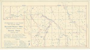
The document represents a plan item is a plan and topographic map of the Grazing Areas of the Delaware Project Area in Delaware County, Oklahoma. "The small fenced areas are farms, mostly I.R. [and] R. units assigned to Indians." Site plan (topographic map; diazotype, blueline print); 10 15/16 x 19 3/4 inches; Annotations (red, pencil) along some of the existing fences.
Dates
- Creation: 1939-1974
Creator
- From the Collection: Kerr, Robert Samuel, United States Senator from Oklahoma (1949-1963); 12th Governor of Oklahoma (1943-1947), 1896-1963 (Person)
Language of Materials
English
Conditions Governing Access:
Certain series of this collection are stored off-site and require prior notice to access. If you wish to view these materials, please contact the Congressional Archives staff to arrange an appointment.
The following series are stored off-site: Clippings and Invitations.
Full Extent
1 pages
Abstract
76th (1939-1941); 77th (1941-1943); 78th (1943-1945); 79th (1945-1947); 80th (1947-1949)
Repository Details
Part of the Carl Albert Center Congressional and Political Collections Repository