North Canadian River Investigations, New Mexico-Oklahoma-Texas, Basin Map, 1942-01-22
Item — Box: OS 7
Identifier: CAC_CC_031_14_0000_7_207
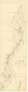
North Canadian River Investigations, New Mexico-Oklahoma-Texas, Basin Map, 1942-01-22
Scope and Contents
The document represents a map item is a hydrologic map of the North Canadian River Basin and features symbols and shading of U.S. Army Engineer investigations, U.S. Bureau of Reclamation investigations, and water uses. Hydrologic map (regional); 10 1/2 x 34 1/8 inches; 280-D-5; Shading (blue, green, red pencil).
Dates
- Creation: 1942-01-22
Creator
- From the Collection: Kerr, Robert Samuel, United States Senator from Oklahoma (1949-1963); 12th Governor of Oklahoma (1943-1947), 1896-1963 (Person)
Language of Materials
From the Collection:
English
Conditions Governing Access:
Certain series of this collection are stored off-site and require prior notice to access. If you wish to view these materials, please contact the Congressional Archives staff to arrange an appointment.
The following series are stored off-site: Clippings and Invitations.
Full Extent
1 pages
Abstract
77th (1941-1943)
Repository Details
Part of the Carl Albert Center Congressional and Political Collections Repository