Revisions of Federal Aid Routes, Denison Lake Area, 1936-1947
Scope and Contents
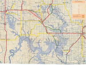
The document represents a map item is a topographic and watershed map of the Denison Lake and Red River area. Map features labeled, annotated, and color-coded routes. Red indicates Federal-Aid Routes; yellow indicates Federal-Aid Secondary Routes; green indicates Abandoned Routes. A few routes are annotated in blue pencil. Additional inscriptions in red pencil specify "lines." Topographic map (watershed map; diazotype, blueline print); 18 3/4 x 25 1/4 inches; Annotations (red, yellow, green, blue); Inscriptions (red, pencil; black, ink).
Dates
- Creation: 1936-1947
Creator
- From the Collection: Kerr, Robert Samuel, United States Senator from Oklahoma (1949-1963); 12th Governor of Oklahoma (1943-1947), 1896-1963 (Person)
Language of Materials
English
Conditions Governing Access:
Certain series of this collection are stored off-site and require prior notice to access. If you wish to view these materials, please contact the Congressional Archives staff to arrange an appointment.
The following series are stored off-site: Clippings and Invitations.
Full Extent
1 pages
Abstract
75th (1937-1939); 76th (1939-1941); 77th (1941-1943); 78th (1943-1945); 79th (1945-1947)
Topical
Repository Details
Part of the Carl Albert Center Congressional and Political Collections Repository