Proposed Improvement, U.S. Highway - 70, Randlett, East to Arkansas State Line, 1936-1947
Scope and Contents
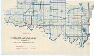
The document represents a plan item is a map of the southern counties of Oklahoma along the Red River from Tillman to McCurtain County and features the proposed improvements to U.S. Highway 70. Green notations indicate present improvement. Red notations and lines indicate areas programmed for P.W. construction or survey and plans for proposed construction. Item is comprised of two sheets that were adhered together but have separated due to the degradation of the adhesive. Section 1 (of 2) features the western counties of Love to Tillman. Section 2 (of 2) features the eastern counties of Marshall to McCurtain. Map (diazotype, blueline print); 20 5/8 x 34 11/16 inches (Section 1); 20 13/16 x 39 7/8 inches (Section 2); Annotations (blue, red, green).
Dates
- Creation: 1936-1947
Creator
- From the Collection: Kerr, Robert Samuel, United States Senator from Oklahoma (1949-1963); 12th Governor of Oklahoma (1943-1947), 1896-1963 (Person)
Language of Materials
English
Conditions Governing Access:
Certain series of this collection are stored off-site and require prior notice to access. If you wish to view these materials, please contact the Congressional Archives staff to arrange an appointment.
The following series are stored off-site: Clippings and Invitations.
Full Extent
1 pages
Abstract
75th (1937-1939); 76th (1939-1941); 77th (1941-1943); 78th (1943-1945); 79th (1945-1947)
Repository Details
Part of the Carl Albert Center Congressional and Political Collections Repository