General Highway and Transportation Map, McCurtain County, Oklahoma, 1936
Scope and Contents
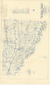
The document represents a map item is a topographic map of McCurtain County, Oklahoma. U.S. Highway 70 from Broken Bow to the state line is featured in red pencil along with an inscription in pencil: "Present Type" "U.S. 70-Broken Bow East to Ark. St. Line" "Standard Grade and Drainage" "26' Road Crown" "Traffic Bound Surface Course 500 C.Y. pr. Mile". Topographic map (polyconic projection; diazotype, blueline print); 17 7/8 x 30 1/4 inches; Sheets 2 of 2 Sheets; Annotation (red, pencil) highlighting U.S. Highway 70; Inscription (pencil).
Dates
- Creation: 1936
Creator
- From the Collection: Kerr, Robert Samuel, United States Senator from Oklahoma (1949-1963); 12th Governor of Oklahoma (1943-1947), 1896-1963 (Person)
Language of Materials
English
Conditions Governing Access:
Certain series of this collection are stored off-site and require prior notice to access. If you wish to view these materials, please contact the Congressional Archives staff to arrange an appointment.
The following series are stored off-site: Clippings and Invitations.
Full Extent
1 pages
Abstract
75th (1937-1939)
Repository Details
Part of the Carl Albert Center Congressional and Political Collections Repository