Oklahoma Highway Commission Federal Aid Sketch Map of PWS 1, 1943-12-07
Scope and Contents
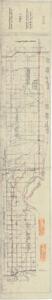
The document represents a plan item is an area plan of the road construction and projects surrounding the Red River. This plan features Item No. 70 Jefferson County and Item No. 90 Love County as well as annotations in red and green pencil along various routes. Pink labels adhered to bottom edge of plan detailing the estimated costs of resurfacing specific sections of State Highway 32. Area plan (orthographic projection; map; diazotype, blueline print); 11 1/4 x 63 3/4 inches; Annotations (red, green pencil) along various project routes.
Dates
- Creation: 1943-12-07
Creator
- From the Collection: Kerr, Robert Samuel, United States Senator from Oklahoma (1949-1963); 12th Governor of Oklahoma (1943-1947), 1896-1963 (Person)
Language of Materials
English
Conditions Governing Access:
Certain series of this collection are stored off-site and require prior notice to access. If you wish to view these materials, please contact the Congressional Archives staff to arrange an appointment.
The following series are stored off-site: Clippings and Invitations.
Full Extent
1 pages
Abstract
78th (1943-1945)
Repository Details
Part of the Carl Albert Center Congressional and Political Collections Repository