Roger Mills County, Oklahoma, 1936-1947
Scope and Contents
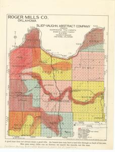
The document represents a map item is a geological survey of Roger Mills County, Oklahoma and features color-coded shading for alluvium and terrace deposits. Wells developed for irrigation are annotated in pencil. Inscription states: Surface Geology indicates sufficient water for irrigation. Geological survey (color); 11 x 8 1/2 inches; Map No. 0-65-1148; Shading (red, pencil); Annotations (pencil) of irrigation wells; Inscriptions (pencil).
Dates
- Creation: 1936-1947
Creator
- From the Collection: Kerr, Robert Samuel, United States Senator from Oklahoma (1949-1963); 12th Governor of Oklahoma (1943-1947), 1896-1963 (Person)
Language of Materials
English
Conditions Governing Access:
Certain series of this collection are stored off-site and require prior notice to access. If you wish to view these materials, please contact the Congressional Archives staff to arrange an appointment.
The following series are stored off-site: Clippings and Invitations.
Full Extent
1 pages
Abstract
75th (1937-1939); 76th (1939-1941); 77th (1941-1943); 78th (1943-1945); 79th (1945-1947)
Topical
Repository Details
Part of the Carl Albert Center Congressional and Political Collections Repository