Flood Prevention Project Overview for Bixby, Oklahoma, 1945
Scope and Contents
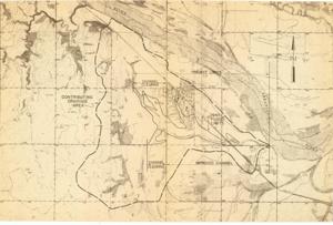
The document represents a map item is a relief and watershed map of Bixby, Oklahoma and its vicinity. Map features boundaries of the 1945 flood limits and contributing drainage area. The clearing channels, project limits, and improved channel are indicated on the map. Additionally, oil wells, levees, and the Arkansas River are indicated on the map. Relief map (watershed map; diazotype, blackline print); 10 7/16 x 15 13/16 inches.
Dates
- Creation: 1945
Creator
- From the Collection: Kerr, Robert Samuel, United States Senator from Oklahoma (1949-1963); 12th Governor of Oklahoma (1943-1947), 1896-1963 (Person)
Language of Materials
English
Conditions Governing Access:
Certain series of this collection are stored off-site and require prior notice to access. If you wish to view these materials, please contact the Congressional Archives staff to arrange an appointment.
The following series are stored off-site: Clippings and Invitations.
Full Extent
1 pages
Abstract
79th (1945-1947)
Topical
Repository Details
Part of the Carl Albert Center Congressional and Political Collections Repository