General Highway and Transportation Map, Tulsa County, Oklahoma, 1945-1962
Scope and Contents
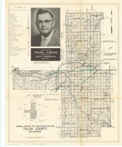
The document represents a map item is a road map, "compliments" of "Frank O'Brien, Democrat for County Commissioner, District No. 1." This map depicts the improvements and proposed improvements to the Tulsa County transportation system. Highlighted with shading in green pencil are the Turnpike, the proposed North-side Highway Loop, and a couple unnamed proposed improvements. Road map (political poster); 16 13/16 x 13 7/16 inches.
Dates
- Creation: 1945-1962
Creator
- From the Collection: Kerr, Robert Samuel, United States Senator from Oklahoma (1949-1963); 12th Governor of Oklahoma (1943-1947), 1896-1963 (Person)
Language of Materials
English
Conditions Governing Access:
Certain series of this collection are stored off-site and require prior notice to access. If you wish to view these materials, please contact the Congressional Archives staff to arrange an appointment.
The following series are stored off-site: Clippings and Invitations.
Full Extent
1 pages
Abstract
79th (1945-1947); 80th (1947-1949); 81st (1949-1951); 82nd (1951-1953); 83rd (1953-1955); 84th (1955-1957); 85th (1957-1959); 86th (1959-1961); 87th (1961-1963)
Repository Details
Part of the Carl Albert Center Congressional and Political Collections Repository